
Walking through the streets of downtown Indianapolis feels incredible, but stopping to understand the history beneath your feet can leave you with a profound appreciation for the city. A modern skyline isn’t just a collection of tall buildings; it’s a living testament to centuries of planning, struggle, and growth.
Understanding how this vibrant area evolved is crucial for anyone who wants to truly experience the heart of Indiana. From its ambitious early city plans to its towering monuments, the capital holds stories that shaped the entire Midwest.
If you want to test your local knowledge, pay close attention to the details shared below. At the end of this historical journey, a short quiz will challenge what you have learned about the Crossroads of America.
The Birth of a City: Indianapolis’s Early Days
From State Capital to Bustling Hub
The story of downtown Indianapolis begins with a vision. In 1821, surveyor Alexander Ralston helped design the original layout for the city. Ralston created a brilliant “Mile Square” plan consisting of a central circle with four radiating diagonal avenues. He aligned the 10-block-by-10-block grid with the cardinal directions. Meridian Street, named after the Latin word for midday, divided the city directly into east and west sections.
This careful planning set the stage for a highly organized, easy-to-travel city. Indiana Avenue quickly became one of the most vibrant diagonal streets, establishing a cultural framework that would serve the community for generations.
Architectural Marvels of Early Indianapolis
As the city expanded, builders utilized local resources to construct lasting marvels. Indiana is famous for its oolitic limestone, sourced largely from Owen County. This sturdy, beautiful stone became the foundation for many early civic buildings and monuments, giving the city a distinct, unified architectural feel. Even today, traces of 20th-century period revivals, featuring red clay tile roofs and unique masonry, can be spotted as you explore the historic districts immediately surrounding the downtown core.
Downtown’s Evolution Through the Centuries
The Canal’s Enduring Legacy
Waterways often dictate the success of early American cities. The Indiana Central Canal was an ambitious project intended to connect the Wabash and Erie Canal directly to the Ohio River. Funded by the Mammoth Internal Improvement Act, construction began with high hopes.
However, the state faced bankruptcy just three years into the build, forcing the project to stop. In 1850, the state sold the unfinished canal to private parties as part of a debt retirement program. Today, the revitalized Canal Walk serves as a beautiful recreational area, turning a 19th-century financial failure into a beloved modern asset.
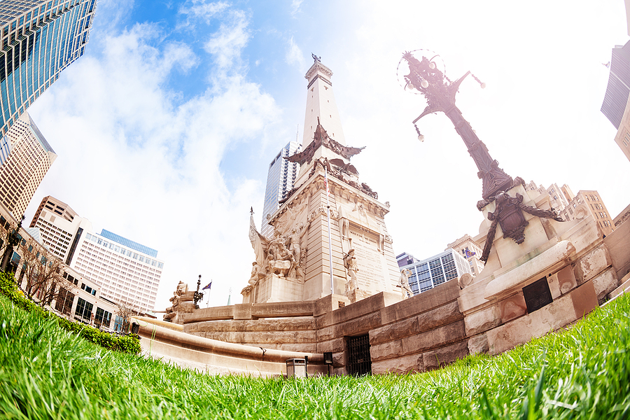
Monument Circle: A Symbol of Indiana
At the very center of Ralston’s original city plan sits Monument Circle, home to the magnificent Soldiers and Sailors Monument. Dedicated in 1902, this obelisk-shaped structure is a staggering 284 feet and 6 inches tall—only 15 feet shorter than the Statue of Liberty.
It holds a special place in history as the first monument in the United States dedicated specifically to the common soldier. Building the monument cost $598,318, a massive sum at the turn of the century. The towering limestone structure continues to watch over the city, serving as an iconic gathering place for locals and visitors alike.
Hidden Gems and Local Lore
Lesser-Known Historical Sites
Beneath the bustling streets lies a hidden world. The Indianapolis City Market Catacombs are over a century old and represent one of only a dozen catacomb sites in the United States. Originally, they served as a convenient space to transport goods and store ice for the above-ground marketplace.
Just a short walk away is the Slippery Noodle Inn. Established in 1850 as the Tremont House, it holds the title of the oldest commercial building and oldest bar in the city. Featuring an original tin ceiling from 1890, the building is steeped in local lore, with rumors of ghosts and hidden histories echoing through its historic halls.
Fascinating Stories from Indianapolis’s Past
You might wonder how Indiana earned the famous nickname “Crossroads of America.” Indianapolis was historically the primary hub for several major rail lines and intersecting national roads. Because so many travelers passed through the center of the state, the city became casually known by this moniker. The title became so deeply ingrained in local identity that Indiana officially adopted “Crossroads of America” as its state motto in 1937.
Revitalization and Modern Downtown
Preserving History, Embracing Progress
Cities must adapt to survive, and downtown Indianapolis has undergone massive transformations since the late 20th century. During the 1980s and 1990s, major projects like the construction of Circle Centre Mall helped bring retail and entertainment back to the city’s core.
Rather than tearing down every old structure, developers often chose to preserve historic facades. This careful balance ensures that the city retains its classic charm while providing modern amenities for a growing population.
The Future of Downtown Indianapolis
The evolution of the city is far from over. Areas that were once purely commercial are transforming into mixed-use neighborhoods. Redevelopment plans for aging structures emphasize dining, entertainment, and residential units, ensuring that the downtown area remains a lively, walkable district for decades to come.
FAQ Section
Who designed the original layout of Indianapolis?
Alexander Ralston designed the original 1821 “Mile Square” plan for Indianapolis, featuring a central circle and radiating diagonal avenues.
Why is Indianapolis called the Crossroads of America?
The city earned the nickname because it served as a major intersection for numerous national rail lines and highways. It became the official state motto in 1937.
What is the oldest bar in Indianapolis?
The Slippery Noodle Inn, originally opened in 1850 as the Tremont House, is the oldest continuously operating bar and commercial building in the city.
How tall is the Soldiers and Sailors Monument?
The monument stands at 284 feet and 6 inches tall, making it just 15 feet shorter than the Statue of Liberty.
Take a Short Quiz!
Test your knowledge of Downtown Indianapolis history. Take the quiz below and match your answers to the answer key below!
1. What was the name of the surveyor who designed the “Mile Square” plan in 1821?
A) George Washington
B) Alexander Ralston
C) John Dillinger
2. The unfinished Indiana Central Canal was originally intended to connect the Wabash and Erie Canal to which major body of water?
A) Lake Michigan
B) The Mississippi River
C) The Ohio River
3. What specific type of stone, sourced from Owen County, was used to build the Soldiers and Sailors Monument?
A) Granite
B) Oolitic limestone
C) Marble
4. Which historic location features an underground area that was once used to store ice and transport goods?
A) The Slippery Noodle Inn
B) The Soldiers and Sailors Monument
C) The City Market Catacombs
Answer Key: 1. B, 2. C, 3. B, 4. C
Keep Exploring the Heart of the City
Learning about the rich history of downtown Indianapolis provides a deeper connection to the streets you walk every day. From the towering heights of Monument Circle to the historic depths of the City Market Catacombs, the capital is filled with fascinating stories waiting to be shared.
After spending the day exploring these historic sites, you will certainly need a great place to relax and recharge. Be sure to visit English Ivy’s Eatery & Pub for an amazing, LGBTQIA-friendly environment serving up delicious brunch, lunch, dinner, and late-night drinks.
Related Post: Discover the Historic Saint Joseph Neighborhood in Downtown Indianapolis